

The Isomaps routing service is an indispensable API designed to simplify your life by seamlessly integrating routing and navigation features into your web or mobile application. Isomaps makes it easy for developers to add reliable and precise navigation capabilities, significantly enhancing user experience and providing the most efficient routes for all travel needs.
View documentationThe Optimized Route service swiftly calculates the time and distance between multiple starting locations and destination points. It then arranges them in the most efficient order for the route, providing a clear and optimized path. This service is designed to make your journey planning effortless and more efficient, saving you time and resources.
View documentation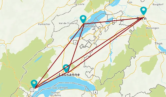
The Isomaps time-distance matrix service quickly computes the time and distance between a series of locations, displaying the results in a convenient matrix table. This service simplifies your planning process by providing clear and precise information, making it easier to manage and optimize travel routes.
View documentationThe Isomaps isochrone service calculates reachable areas within specified time intervals from a particular location and presents these areas as contours of polygons or lines. These can be easily displayed on a map, making it simple to visualize and analyze the accessibility of different regions based on travel time. This service enhances planning and decision-making by providing clear, visual representations of reachable zones.
View documentation

The Isomaps route isochrone service calculates areas that can be reached within specified time intervals along a given route, rather than from a single point. It provides these reachable regions as contours of polygons or lines, which can be easily displayed on a map. This service offers a clear visual representation of accessibility along a route, aiding in effective planning and analysis.
View documentationIsomaps' elevation lookup service provides digital elevation model (DEM) data upon request. This service allows you to obtain accurate elevation information quickly and efficiently, supporting various applications that require precise topographical data.
View documentation

In today's fast-paced digital world, accurately mapping locations is crucial for a wide range of applications, from logistics to travel planning. Our Geocoding API service is designed to meet this need by converting physical addresses into precise geographical coordinates. This powerful tool ensures that you can efficiently manage and utilize location data, enhancing the overall effectiveness of your operations. Whether you are managing a fleet of vehicles, running a travel business, or developing location-based services, our Geocoding API offers a reliable and accurate solution to meet your requirements. The Geocoding API is a powerful tool that converts addresses, such as '120 route de Grenoble Lyon,' into geographic coordinates like 'lat': 45.71016, 'lng': 4.97837. This service simplifies location-based applications by providing precise and reliable latitude and longitude data for any given address.
View documentationThe Isomaps Reverse Geocoding API offers users a convenient tool to transform coordinates, such as 4.97837, 45.71016, into a human-readable street address, street component, or geographical location. This service enhances location-based applications by providing accurate and easily interpretable address data from latitude and longitude inputs.
View documentation

Isomaps service delivers real-time information on current road congestion and incidents across all the countries where it is available. This service helps users stay updated on traffic conditions, enhancing their ability to plan routes more effectively and avoid potential delays.
View documentationThe service provides traffic incident data packaged in vector tiles, which are vector representations of squared sections. This format allows for efficient and detailed visualization of traffic incidents, enabling users to integrate comprehensive traffic information into their applications for better route planning and traffic management.
View documentation
With Isomaps, you can access current weather data for any location on Earth. This service provides accurate and up-to-date weather information, helping users stay informed about the weather conditions no matter where they are, enhancing travel planning and decision-making.
View documentationWith Isomaps, you can access current weather data for any city on Earth. This service delivers accurate and up-to-date weather information, ensuring users are always informed about the weather conditions in their chosen city, enhancing travel planning and daily activities.
View documentation
Isomaps offers a 5-day weather forecast accessible for any location worldwide, providing detailed weather data at 3-hour intervals. This service ensures users receive timely and accurate weather predictions, enabling better planning and preparedness for various weather conditions.
View documentationIsomaps provides a 16-day daily weather forecast for any location worldwide. This service delivers comprehensive daily weather data, allowing users to stay informed and plan their activities well in advance, ensuring they are prepared for any weather conditions.
View documentation